Metro Area Stations |
New Carrollton Metrorail Station
New Carrollton Metrorail Station
The land uses planned within one-half mile of the Metrorail are commercial, office and a business park. The Landover and Vicinity Master Plan (1993) is the applicable master plan for this Metro Station area. Sites in Public Ownership WMATA owns 35.7 acres including the station and parking area. The state of Maryland owns approximately 9 acres (currently used for surface parking). The County owns approximately 8 acres within one-quarter mile of the station. Quick Facts (WMATA Data 2010) 
 New Carrollton is a unique transportation hub within the Washington region, combining a heavily utilized Metrorail and Metrobus end of line station with Amtrak, MARC, The Bus, and intercity bus lines at the intersection of two major highways. The new Purple Line light rail system is planned to traverse Montgomery and Prince George’s Counties from Bethesda to New Carrollton (terminating on the north parcel). The Internal Revenue Service (IRS) occupies a three-building 1.2 million sf complex north of the station that houses approximately 5,000 employees. There is a pedestrian bridge connecting the IRS facility and the north station entrance. The 200 acre Metro East Office Park is located to the south and east of the station. In addition to office buildings, the Park contains a Marriott Courtyard Hotel. New Carrollton is a unique transportation hub within the Washington region, combining a heavily utilized Metrorail and Metrobus end of line station with Amtrak, MARC, The Bus, and intercity bus lines at the intersection of two major highways. The new Purple Line light rail system is planned to traverse Montgomery and Prince George’s Counties from Bethesda to New Carrollton (terminating on the north parcel). The Internal Revenue Service (IRS) occupies a three-building 1.2 million sf complex north of the station that houses approximately 5,000 employees. There is a pedestrian bridge connecting the IRS facility and the north station entrance. The 200 acre Metro East Office Park is located to the south and east of the station. In addition to office buildings, the Park contains a Marriott Courtyard Hotel.
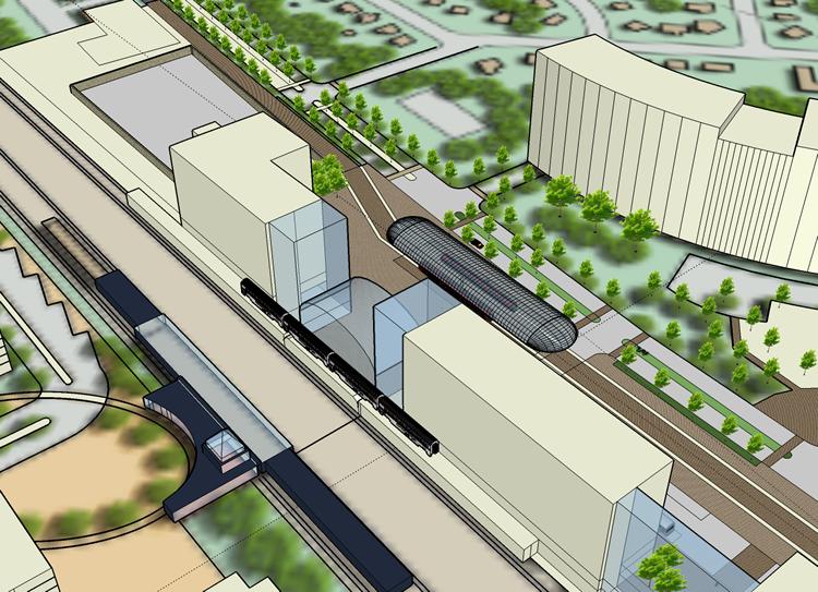
 The Prince George’s County Transit District Overlay Zoning Map Amendment for New Carrollton
The New Carrollton station area is envisioned as an exciting and livable transit oriented community with a mix of offices, stores, residences and hotel rooms in a location with unparalleled transportation access to the National Capital region. The Prince George’s County Transit District Overlay Zoning Map Amendment for New Carrollton (the “TDDP/TDOZ”). The TDDP calls for the transformation of the area to include up to 3,000 housing units; 2,600,000 square feet of office/commercial space; an extensive system of open spaces; an efficient street network that feels welcome to pedestrians, bicyclists, and vehicular traffic alike; and a Metro station rebuilt as a grand urban transportation center. Read more about this plan A Technical Assistance Panel Report: Catalyzing Development Around The New Carrollton Station area (July 2007) This comprehensive study with substantial stakeholder input resulted in a true framework for the station area. The study’s vision transforms the station area into a lively, urban, mixed-use community – the downtown of Prince George ’s County – complete with pedestrian- friendly streets, an integrated open space framework, and six distinct character areas. View/download this study

Approved New Carrollton Transit District Development Plan and Transit District Overlay Zoning Map Amendment (May 2010) This document contains text and maps of the approved transit district development plan (TDDP) and transit district overlay zoning map amendment for the New Carrollton Metro Station and vicinity. This plan contains an amended TDDP and transit district overlay zone (TDOZ) which together replace the 1989 Approved New Carrollton Transit District Development Plan. The plan also amends the 2002 Prince George's County Approved General Plan, the 1994 Bladensburg-New Carrollton and Vicinity Approved Master Plan and Sectional Map Amendment, and the 1993 Landover and Vicinity Approved Master Plan and Sectional Map Amendment.
The Metro Core – Mixed-use heart of the transit district development plan (TDDP) with medium- to high-density commercial, retail, and residential uses.
|


 Move of Maryland Housing Department to New Carrollton Officially Announced